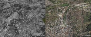
 On February 4, 2010, Google.com announced that it had added an historical imagery feature to Google Earth.
The historical imagery feature gives people a unique perspective on the events of the past using today’s latest mapping technology. We hope that this World War II imagery will enable all of us to understand our shared history in a new way and to learn more about the impact of the war on the development of our cities.
You will be able to compare war time reconnaissance images to modern satellite photos to gain a unique perspective of the destruction on such cities as Stuttgart (Germany) — that experienced over 50 air raids. I am not sure if the destruction is due completely to Allied air raids or if there was ground fighting that took place as well. Images from Italy, Poland and France are also available.
Here is a nice presentation on what it looks like before you do ahead and download Google Earth: